Edmun B. Richmond, W4YO
Expand your DX world by investigating the far-flung lands behind those QSL cards.
Contacting faraway places with strange-sounding names has always been a top interest among hams. As DXers we may spend hours trying to make a 1 minute contact to add to our DXCC total. Occasionally, we’ll go to a world atlas to locate the place we have just worked, then return to combing the bands for the next rare DX contact. When conditions are poor, we might spend a bit more time researching more information in an atlas or encyclopedia, or on the Internet. When you investigate the geography, history and culture of the DX entities you contact, DXing takes on more meaning than just carving successive notches on your DXCC belt. This article will delve into the some fascinating facts and histories related to several DXCC entities, in the hope of whetting your interest in this aspect of DXing.
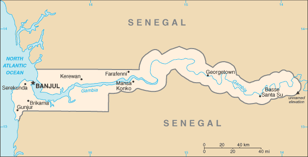
The Senegal-Gambian International Border (DXCC prefixes 6W, C5)
The present boundaries of Senegal and The Gambia form a geographical oddity. They were established in 1904 by agreement between France and Great Britain, the two European countries that had colonized and fought over the region since the mid 16th century. The strange configuration of The Gambia is due to the fact that its border with Senegal follows the River Gambia some 200 miles into the interior, effectively cutting Senegal in two. The Gambia is the smallest country in Africa, with an area of only 4363 square miles.
The width of the country varies from 30 miles at the mouth of the river, to 7 miles in the interior. The river itself is tidal and is navigable inland from the coast for about 150 miles. Small ocean-going ships can travel up river to the town of Kuntaur. Small steamers can navigate the river for 140 miles farther upstream.
All of this has had the effect of slicing off the Senegalese southern province of Casamance from the rest of the country. In order for overland traffic to proceed between Casamance and the rest of Senegal, it must cross the international border between The Gambia and Senegal twice, once entering the Gambia and once leaving to return to Senegalese soil. The primary travel route is the Trans-Gambian Highway, which runs 21.7 miles through the center of The Gambia, in a north-south direction. There is no bridge at the Gambia River, which must be traversed by ferry. Although The Gambia was once a British colony, vehicular traffic drives on the right instead of the left, as in the United Kingdom and other former British colonies.
A favorite urban legend in The Gambia concerning the methodology of establishing the country’s border with Senegal refers to a British gunboat that ran up the central channel of the Gambia River and every few yards fired a cannon ball to each side of the river. Where those cannon balls landed became the international border. I can find no evidence that this actually took place, but it makes a novel anecdote. The actual mapping of the border was accomplished by a precise survey undertaken by the Anglo-French Boundary Commission in 1889.
The official name of the country is two words: The Gambia. The word “The” was added to avoid confusion with Zambia in southern Africa. Mail and freight were constantly being misdirected so the “The” was added to the name.
Republic of Kiribati (DXCC prefixes T30, 31, 32, 33)
Kiribati, previously called the Gilbert Islands, consists of three widely separated island groups in the central Pacific Ocean. It is comprised of 32 atolls and one larger island. Although its total land area is only 313 square miles, the individual islands are scattered across more than 1,351,000 square miles of ocean.
Although the English alphabet is used on Kiribati, the letters represent the sounds of Gilbertese, the local language. The actual name of the country is not pronounced as it is spelled in English, but is pronounced “kiribas.” The former Christmas Island is locally spelled “kirimati,” but is pronounced “kirismas.”
The country straddles the equator and its easternmost point approaches the International Date Line. Kiribati has three time zones (UTC +12, +13, +14). The island groups that make up this country are West Kiribati (T30), the Phoenix Islands (now Central Kiribati (T31) and the Line Islands (now East Kiribati (T32). Before they attained independence from Great Britain, all three groups were on the DXCC List with the prefix of VR1.
Five of the Line Islands are uninhabited and with the exception of Kanton Island, the Phoenix group is also uninhabited.1 The coral island of Banaba (T33), formerly known as Ocean Island, is also a part of Kiribati. This solitary island is located west of the Gilbert chain.
In order for the business week to be the same in all parts of the country, in 1995, Kiribati moved the International Date Line east to include the Line Islands. The move also made Kiribati the first nation to see the sunrise of each new day.
There are two important historical events related to Kiribati. First, the island of Tarawa, in the Gilberts, is etched in the historical memory of the US Marines as one of the bloodiest battles of World War II was fought there.
Second, mounting evidence appears to point to the island of Nikumaroro, in the Phoenix group, as the final resting place of famed aviator Amelia Earhart and her navigator, Fred Noonan. In July 1937, they were attempting a round-the-world flight following the equatorial route when their airplane ran out of fuel and disappeared in the Pacific. There has been a general belief that they were able to land on one of the many small Pacific islands but no evidence has come to light as yet to verify that. Several expeditions by the American company TIGHAR Foundation have unearthed Western or European-type artifacts on this uninhabited island that might have belonged to the intrepid duo.
On a more foreboding note, Kiribati is expected to become the first country to be swallowed by the rising ocean level brought about by global climate change. The country has already asked both Australia and New Zealand to accept Kiribati citizens as permanent refugees in the event this calamity occurs.
One last point of interest is that the island of Banaba is a geopolitical anomaly. Although it is part of Kiribati, it is administered from Rabi Island, which is part of Fiji.
Africa’s Four Corners and the Caprivi Strip (DXCC prefixes V5, A2, Z2, 9J)
In southern Africa, there is a narrow strip of land that was formed from the political needs of the European colonial powers. This panhandle area is Namibian territory and protrudes eastward about 280 miles between Botswana to the south and Angola and Zambia to the north. Known as the Caprivi Strip, it is named after German Chancellor Leo von Caprivi. In the late 1800s, Germany ruled Namibia under the name of Afrika Sudwest (Southwest Africa). By annexing the Caprivi Strip, Germany hoped to acquire access to the Zambezi River, which they thought would be a trade route to the east African coast and the German territory of Tanganyika (today’s Tanzania).
Unfortunately, that trade route never developed due to the shallow, rock-filled waters of the Zambezi. After Namibian independence, a territorial dispute took place between Namibia and Botswana regarding the placement of the border relative to the Chobe River and a large island in mid-stream. In 1999, the International Court of Justice ruled that the main channel was part of Caprivi but the island belonged to Botswana.
There is a possibility that a quadripoint exists where the borders of Namibia, Botswana, Zambia and Zimbabwe come together, much like our Four Corners area at the junction of Arizona, Colorado, New Mexico and Utah. Claims have been made that the area at the confluence of the Chobe and Zambezi Rivers is the “Four Corners of Africa,” with the actual quadripoint in the middle of the river.
An international quadripoint is an extremely rare occurrence. The reality is that although these four countries do indeed meet very closely and are separated by extremely short distances, no formal border agreement among the four African states has ever been concluded. There is only a de facto local border between Zambia and Botswana. In order to resolve the issue of a true quadripoint, the four states would have to conduct precise boundary surveys to satisfy the question and to determine the actual location of the quadripoint. A plan to build a bridge across the Zambezi at Kazungula between Botswana and Zambia may provide such an opportunity.
Australian Indian Ocean Territories (DXCC prefix VK9)
The Australian Indian Ocean Territories comprises Christmas Island and Cocos (Keeling) Islands Archipelago. Christmas Island is located 1600 miles northwest of Perth, Western Australia and 606 miles northeast of the Cocos (Keeling) Islands. Cocos (Keeling) is located southwest of Christmas Island and midway between Australia and Sri Lanka. Cocos (Keeling) is located on almost the exact opposite side of the Earth from the Costa Rican Cocos Island, in the eastern Pacific Ocean (DXCC prefix TI9).
Both Australian islands are tropical in nature; warm but moderated by the southeast trade winds. While the Cocos (Keeling) Islands are low and flat with a profusion of palm trees; Christmas Island is the top of an ancient volcano and features tropical forests, steep cliffs and a central plateau. Commercially, Christmas Island has important deposits of high grade phosphate.
Of the two islands, Cocos (Keeling) arguably has the most storied and unusual history. Captain William Keeling was the first European to see the islands in 1609. In 1814, Captain John Clunies-Ross went ashore to explore, planted a Union Jack and planned to return with his family to settle on the islands. However, a rich Englishman by the name of Alexander Hare also wanted to retire there and hired a sea captain, by chance the brother of Clunies-Ross, to transport him and a harem of 40 Malay women to the islands to establish his own private residence. Apparently, Hare was a bit of a bounder and couldn’t stand the rigid life that European mores and conventions dictated.
When Clunies-Ross returned to the islands 2 years later with his family, he found Hare ensconced on the island with his private harem. The two men instantly disliked each other and a feud developed. Clunies-Ross’ sailors began a small war and took control of the island, harem and all. In the interim, Hare’s women began leaving him and taking up residence with the sailors who had arrived with Clunies-Ross. Hare was so despondent over these events that he left the islands and settled on Java, where he later died.
The British Empire annexed the islands in 1857. One of the first naval battles of World War I took place there. The British had a telegraph station on Direction Island, one of the islets in the Cocos (Keeling) archipelago, that was an important link between the United Kingdom, Australia and New Zealand. A German light cruiser destroyed the station.
During World War II, the cable station was also a vital link and the Japanese took over several of the smaller islets in the area, but strangely never invaded Direction Island or attacked the cable station. On November 23, 1955, Australia assumed control of the islands.
Christmas Island has had a more sedate history, but it is still interesting. Captain William Mynors first sighted the island on Christmas Day, 1643. It is very isolated and has seen a limited amount of human activity over the centuries. This has resulted in its flora and fauna developing in seclusion without foreign influences of cross-pollination and crossbreeding.
Two-thirds of the island is an Australian national park. Over the years, the island has been governed in a rather convoluted manner. This began with joint administration by the British Phosphate Commissioners and District Officers from the United Kingdom Colonial Office and followed a complicated path ultimately ending in the Crown Colony of Singapore. At the request of Australia, the United Kingdom transferred sovereignty to Australia in 1957, but Australia had to pay Singapore 2.9 million pounds in compensation for the value of the phosphate found on the island.
The first attempt to explore the island took place in 1857. High grade phosphate was discovered on the island in 1887, and the British Crown annexed it in 1888. Soon after, George Clunies-Ross, our old friend of Cocos (Keeling) fame established a small settlement as a base of operations for collecting timber and other supplies to be used on Cocos. Phosphate mining began in earnest on Christmas Island in the 1890s.
Things remained quiet until the outbreak of World War II. Japan attacked Christmas Island because of its rich deposits of phosphate. After several skirmishes back and forth, the Japanese subdued the British garrison and occupied the island in March 1942. Some of the remaining British construction workers and troops escaped to the jungle and initiated acts of sabotage against the Japanese. The British returned in October 1945 and reoccupied the island.
The diverse flora and fauna that has developed on Christmas Island is of great interest to naturalists. It is home to at least 18 plant species as well as several species and sub-species of animal found nowhere else in the world. In addition, land crabs and red crabs abound. The annual November migration of the red crabs has been the subject of several television programs. This migration involves 100 million crabs and takes place after the start of the wet season and in tune with the cycle of the moon. Christmas Island is also an important sea bird sanctuary.
Even though Christmas and Cocos (Keeling) are isolated, technology has reached these far-flung outposts. Both have telephone, television, radio and broadband Internet services. Satellite links to Western Australia supply all these services. Christmas Island is close enough to Indonesia that many Indonesian stations are also available and provide additional program material.
Wrap-up
As you can see by now, DXing can be more than just adding to your list of entities worked and confirmed if you do a little research. Of course, it’s fun and rewarding to work a new country, as well as to receive that QSL, but it doesn’t have to end there. If you have the time or desire to dig around, you can come up with interesting facts and history about the places you have contacted and increase your own personal knowledge of world geography and world events.
If you are a newcomer to the DX game, you probably want to spend all your time working new ones. As you add to your entity total, however, you’ll find the new ones come less frequently, especially when you’re closing in on the Honor Roll. That may be the perfect time to learn about the entities you have contacted and those you haven’t yet reached. I can say that researching entities not only helps me broaden my worldly horizons, but it buoys my interest in the hobby as I wait for the next new one to come along. After 56 years of hunting DX, they certainly don’t come along too often anymore!
So spend a little time when the bands are cold learning about the many lands that share our radio world. If you do, the next time you contact a DX station you will have more to say than just “you’re 5-9.”
ARRL member Edmun B. Richmond, W4YO, better known as Ed, started listening to shortwave in 1948 and has been licensed since 1956. He has held the calls KN4HNA (1956), K4HNA (1956-70), W8KGR (1970-75) and W4MGM (1975-96). In addition, he has held several calls in Europe and Africa. He retired from Georgia Institute of Technology in 2000, as Professor Emeritus, where he held a joint appointment in the Department of Modern Languages and the School of International Affairs. Ed is an avid DXer and a DXCC Honor Roll member. He presently lives with his spouse, Toni, WA4XYL, on Harbor Island, South Carolina and is active on all bands from 80-6 meters. Ed can be reached at 11 Ocean Marsh Ln, Harbor Island, SC 29920, w4yo@arrl.net
1Caroline Island, Flint Island, Malden Island, Starbuck Island and Vostok Island are all valid for the Islands on the Air (IOTA) award.